


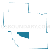
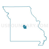
Ulman Voting District, Miller County, Missouri
About
Outline

Summary
| Unique Area Identifier | 609123 |
| Name | Ulman Voting District |
| County | Miller County |
| State | Missouri |
| Area (square miles) | 20.90 |
| Land Area (square miles) | 20.89 |
| Water Area (square miles) | 0.02 |
| % of Land Area | 99.92 |
| % of Water Area | 0.08 |
| Latitude of the Internal Point | 38.13745580 |
| Longtitude of the Internal Point | -92.47531770 |
Maps

Graphs
Select a template below for downloading or customizing gragh for Ulman Voting District, Miller County, Missouri


Neighbors
Neighoring Voting District (by Name) Neighboring Voting District on the Map
- Brumley Voting District, Miller County, MO
- Iberia Rural Voting District, Miller County, MO
- Kaiser Voting District, Miller County, MO
- Osage Voting District, Miller County, MO
- Tuscumbia Voting District, Miller County, MO
Top 10 Neighboring County Subdivision (by Population) Neighboring County Subdivision on the Map
- Glaze township, Miller County, MO (6,804)
- Richwoods township, Miller County, MO (3,243)
- Osage township, Miller County, MO (1,585)
- Equality township, Miller County, MO (1,109)
Top 10 Neighboring Unified School District (by Population) Neighboring Unified School District on the Map
- School of The Osage R-II School District, MO (12,804)
- Iberia R-V School District, MO (3,972)
- Miller County R-III School District, MO (1,414)